Technology Connections
Designing a Magazine
One of the first assignments given in the Design Class I was participating in was to create a magazine. For the content of the magazine I was aiming for topics I am more familiar with and took inspiration from publications like Wired, PCWorld, and MacWorld. I then took the IBM System 360 models I had previously made and placed them in a photoshoot-like set. The feeling that I was trying to emulate was a Technology Magazine from the late 60’s to early 70’s.


Mistic Town Map
Rebuilding a Town
For the Brochure assignment I created one for a bank and I came to the dilemma of branch locations. As previously, I created the newspaper based of the fictitious town of Mistic I decided to remain in the same area for this project. On my last attempt on creating a fictitious town, Mistic was based on handmade drawings and it was not taking much of consideration to the actual landscape it’s supposed to be based on. This resulted in a flat looking map and me going into the rabbit hole that is the AmherstWorldview project. But for this new version the design will work with the landscape rather than opposite.
I first examined the actual location Mistic is based on, Williamsburg MA. In real-life Williamsburg is a small Mill Town in the Pioneer Valley, developed around the Meekin Brook, and the Mill River. For this new design Mistic will conform with Williamsburg’s existing layout but will be slightly modified to fit with requirements that the town of Mistic should have. One of them is a more defined town center with a common area encircled by roadways, with strategic locations for both Town Services and citizen needs. A requirement from the previous design was to include a College. Previously Mistic College was located behind the town hall a couple blocks away, this location is no longer possible so it was moved near a forested area were new roads were made.
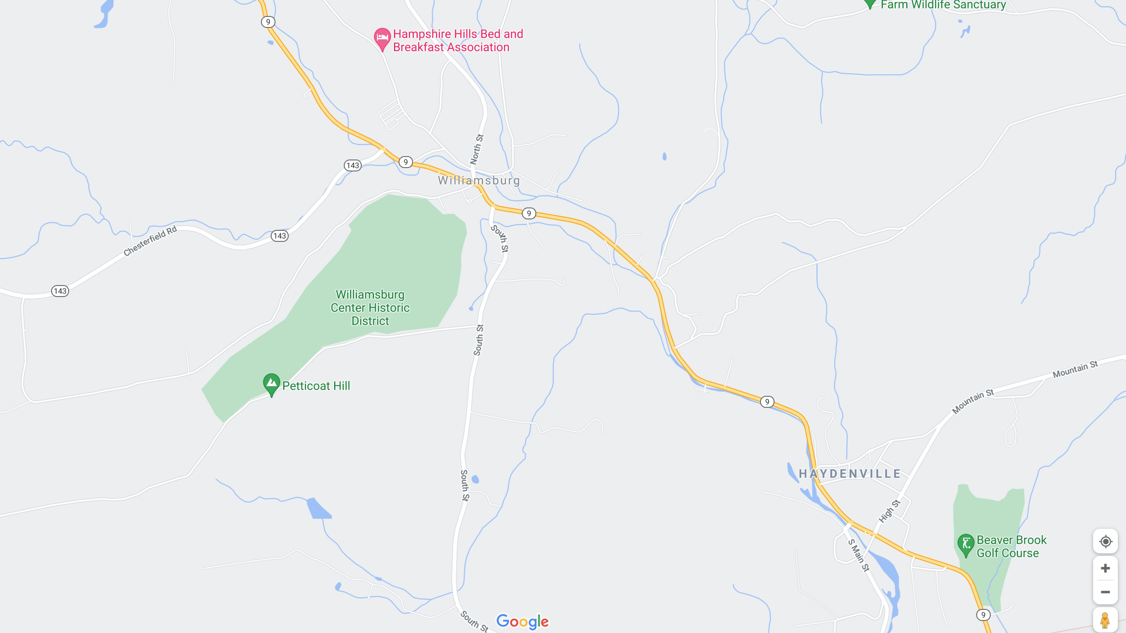

Another requirement was the addition of a railway; emulating the former New York, New Haven & Hartford rail line, but with added passenger service. Besides the requirements, more development in the area was taken to fit with previous renditions, as well with the assumed increase of the population.


Vogel Airlines Shorts
Vogel Airlines is a short video series of advertisements of a fictitious airline. These are supposed to evoke the former glamour flying had in the past. While also contrasting it realities beyond the touristic bubble. These shorts are presented as advertisements the viewer would have see on TV or on their phone before. The shorts were released with different lengths, edits and language. Below are the descriptions of these shorts:
Vogel Airlines
The video uses imagery to invoke thoughts of a “relaxing” or “Perfect” vacation. These are then superseded with shots of an aircraft and the company logo with a narration.
The length is 33 Seconds.
The short was distributed in specific areas on the West Coast, Midwest and Northeast.
Vogel Airlines “Extended”
This video is much shorter, emulating a long running TV commercial which are cut to be made shorter after its initial release. The cut was also taking in consideration the time given to a user before they can skip an ad. When the user is about to click the skip button, the video changes revealing the reality behind the picture-perfect representation of the Ad. Contrasting imagery that breaks the user’s expectations allowing the opportunity for them to watch until the end.
The length is 24 Seconds.
The short was distributed in specific areas on the West Coast, Midwest and Northeast.
Vogel Airlines (Spanish)
Inspirations
This animation was initially part of a larger project and would have acted as a transition point. As the idea kept developing it took a life of its own and became the Vogel Airlines project. The idea of making a fake ad is not new to me. What has abstained me from making one in the past is the balance I’d want to have between a serious ad and a critical one. A serious one is just an Ad, but a critical one would use the same tactics an Ad would use but applying it as a subversion against itself.
An aspect I wanted to emulate in this animation was my experience watching TV in Puerto Rico. Puerto Rico being a U.S. Territory; media coming from the mainland is rather ubiquitous, from Movies, TV Shows, Music, Ads and Slang. Slowly but surely arrives to the island either as the raw creation (like in music) or is translated to Spanish but still keeps its Nationally albeit edited to fit with logistical and market restrictions (due to being an unincorporated territory). For advertising (circa early 2000’s); broadcasted ads had this unique feel to them. Of being noticeably dubbed while also having this old look to them. It would be common to see an Ad from the 90s still being broadcasted even though a newer version of the same Ad was already distributed in the mainland. This gave a feeling of stagnation yet at the same time comfort. This might be due to the multiple economical issues Puerto Rico has faced since the 90’s to this day. A noticeable shift in Advertising in the late 2000’s was the usage of Ads that have been produced for the Spanish-speaking population in the mainland, and came with cultural cues that are not fully present in the Island.
Part of the inspiration also came from the nature of economies based around tourism. In Puerto Rico tourism is one of the major if not biggest industries on the island. Due to this there is a noticeable shift in attention from leaders towards maintaining and beautifying areas that tourist are more likely to gather. Leaving less popular areas under maintained and visually unpleasant. This can be seen more apparent in the condition of roads, roads that are signed and marked as routes for tourist are well maintained that routes taken more often by locals. This can be seen as an obvious decision from leaders but it creates this “backlot look” to the surroundings beyond tourist designated areas. As a host hiding a messy room behind a door, leaders have done the same with how they concentrate their efforts on keeping up an appearance even if it’s a detriment to the local population that has no casual reason to visit those areas.
Advertising the Ads
Due to the experience these shorts were trying to create. These shorts were distributed as Ads across the US. More information about the process and results will be posted on a later date.
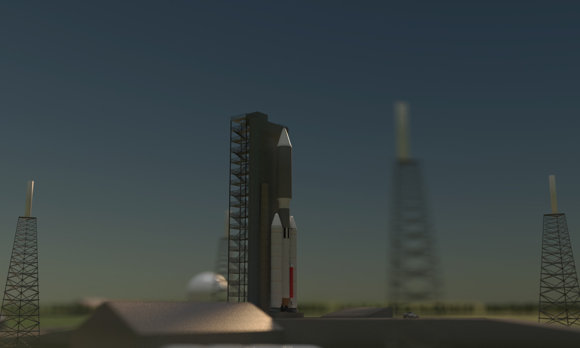
Munch-Man Arcade Machine

Munch-Man
This arcade machine was made was made alongside others to be used as props for a previous animation. It was supposed to act as the in-universe version of Pac-Man.
Measures: 2.85 feet in length, 3.27 feet in width, and 5.71 feet in height.
Artwork done in Moho and Photoshop Animations for the screen done in Moho and edited in Final Cut Pro Modeled in Blender

Mill River Cooperative Bank
Brochure Design
After the Newspaper Assignment in the Design class we were tasked with creating a brochure. In this task we were required to pick from a set of images that was provided and to create both a Logo and a pattern for the brochure. For the content of the brochure I decided to make a Bank that services the Mistic area. The text presented on the brochure was lifted from a Michigan Bank Brochure and was edited to fit with the services I wanted this new bank to provide. This included the removal of any references of the internet or other web services, which were replaced by Telephone services, and the addition of Massachusetts Depositors insurance fund.
For the assets provided not many edits were needed, only one image was changed so its colors reflect the brand of the bank better. For the brand colors I took inspirations from other local banking institutions in the area and for the logo as well. I designed the logo of the bank as a mill to reflect the history of the fictitious town of Mistic. As a former mill town it made sense to me to make the bank logo a mill and it also helped that the real location Mistic is based on has a river called Mill River.
The logo needed to be simple and recognizable but it also had to work with backlit display signs you’d see on the sides of buildings or above an ATM. It consists of a rectangular blue building with a brown roof adorned with a cupola. With a water wheel attached in the front with subtle wavy lines at the bottom to signify water movement. The white areas are meant to be the most bright areas of sign when backlit.
At first I had some difficulty finding a location to place the pattern, as the examples I saw online did not used one and I wanted to keep a professional look. I decided to place the pattern as the background of the Rates Table, I made a series of floating coins with some transparency to keep it subtle.
For the physical location of the Bank and its branches I used locations of real banks in Florence and Northampton and replaced them with Mill River Cooperative Bank Branches. The location of the Main Branch and a secondary one within Mistic were difficult make at first as I wasn’t sure where to place them, to solve this question I created a 2D map of Mistic. In the past (2016) I created a 3D render of Mistic based on some ideas I had and took inspiration from real locations throughout Western Massachusetts. But it wasn’t well thought-out plan when you think about the surrounding environments beyond Mistic. The current map is now based on the actual region is emulating. I then added the remaining addresses to the list.
Because it was required to use some of the images provided, I felt using 3D renders alongside real-life images would be jarring to the viewer. I attempted to look for stock images of banks online but none really fit-in with the vision of the project, and opted to use a 3D render instead. This decision was made with not too much time left. I made a 3D building that had some greco-roman influence. I then placed the building in the location it should be in downtown Mistic, using the old Mistic file from 2016. Lastly I needed an image of the Bank’s staff, I ended up using an image from Wikipedia Editors. I used this image because stock images for “Bank Staff” wore too much professional clothing and I wanted to portray a more “down-to-earth” or “relatable” group. The image is under Creative Commons with Attribution.


The Mistic Examiner
Newspaper Design
For a Design Class I was tasked with creating a newspaper. I started the creation of such by looking at both local and national newspapers. I took heavy inspiration from The Hampshire Gazette, a publication in the Pioneer Valley. I wanted to portray fictitious events and decided to apply it to a fictitious town I created a long time a go. I used Mistic, MA as the location of this publication, and so the Mistic Examiner was born.
Due to the high turn-over rate, I had close to a week to create and finish the newspaper. Most of the time was taken by the design of the layout and the stories that were on the newspaper. We did had the option to use placeholder text but I felt it removed layers of creativity that this project can have. Due to it being set in Mistic, a place only shown through renders. It allowed the possibility of incorporation previous assets into the work. The only new render shown in this project is an image of a rotary phone for a New England Bell advertisement.
It is a similar story for the 2D assets, most of them were imported over to Adobe Illustrator from Moho which had been created in the past for other projects. The maps shown in the project had been used for some animations and was edited to show a gradient of colors to represent temperature maps. The advertisements were made on the spot for those areas in the newspaper, while the weather icons were created for the project.
In terms of the information in the newspaper, accurate weather data was collected. The stories presented in the publication were made to reflect a town with tense local politics, its connection with the state of Massachusetts and the neighboring towns. Some of the information presented was edited from their sources to reflect the fictitious world it came from. These include; addresses, phone numbers, and events.


Swift River Rising: “A Project that Went Under”
INTRODUCTION
Swift River Rising, was an Animation I started to work in the Spring of 2013. The animation was based on the real-life story of the Quabbin Towns. The towns were located on the Swift River Valley, these towns were: Dana, Enfield, Greenwich and, Prescott. The reason of why these towns were the focus of the animation is because these towns were disincorporated from the Commonwealth of Massachusetts to build a reservoir for the City of Boston.
The issue of the need for more water for Boston arose as the city was rapidly expanding around the mid-1800’s. After research done it was decided that the construction of a gravity aided reservoirs would supply enough water to the city. The usage of reservoirs was deemed appropriate as local rivers didn’t supply enough water nor sufficiently clean for consumption. By early 1900’s the construction of the Wachusett Reservoir among others were nearing completion or were already in operation.
In 1922 a study endorsed the construction of a reservoir on the Swift River Valley damming the Swift river to create it. The Swift River was fed from upstream bodies of water in New Salem which came from three streams, the Swift River, the Swift River Middle Branch and the Swift River East Branch. The river continued southward towards Ware and then turning westward draining onto the Connecticut River. In the valley the towns of Dana, Enfield, Greenwich and Prescott were located. These towns were small in size but were interconnected with their surrounding cities. Walking or horseback riding were the primary methods of transportation, the towns also had connections with both the Boston-Albany Railroad and the New London Northern Railroad.
Once the construction of the reservoir started so did the displacement of thousands of residents on the valley. This move was controversial for the residents of these towns, there were protests and a legal lawsuit from the State of Connecticut but were unsuccessful. Some of the buildings were moved to nearby towns, the rest were razed and later submerged. The remaining of the former Township’s land was then given to the nearby communities up to the shoreline of the new reservoir. The destruction of these towns embedded itself into Western Massachusetts culture in which native residents might show distain towards the Boston area or legislature that seems to favor the State Capital and its nearby cities.
STORY
The animation surrounded the events of the announcing of the reservoir, the reaction of the citizens of those towns and the subsequent protests and later demolishing of said towns. The story started white the leader of the community of Enfield, Mr.Adams receives a telegram requesting a meeting with a state representative at his mansion in the Town of Amherst. He expecting him and greeted him from his staircase and asks him to come to his office. There he reveals the plans of constructing a reservoir were their towns lay. After this revelation he instructs him to break the news to the townsfolk in a town meeting.


At said meeting he stood in front of his peers and revealed the news, he was met with opposition as he had expected. Later at his office he met with the meeting’s moderator and discussed the matter further. The moderator reminds him that the townsfolk will not go out without a fight and that he should go and meet with the representative once again. He seems hesitant but still agrees to do it. On his way home he a child approached and asked him about the issue and if he would do something. He gave a surrounding yes as to not let the child down. Once home he is having supper with his wife, she also looked shaken by the news. She pleads to him to see the Representative, he finally agrees in an truthful matter and buys a ticket the next day. After a ride to Boston he meets the representative at his State House office looking over at the protestors with disgust. He tells annoyingly that he cannot do anything the plan is set in motion he suggest to discuss the matter with the main town representative of Amherst.


On his way back home he meets this “Female Fatale” archetype on the train’s lounge cabin. After some small talk she warms him and tells him to leave the matter alone, he disagrees. Next day he arrives to Amherst on the hopes he might find support on rescuing his town from destruction. Sadly his hopes weren’t met as this town didn’t have enough power to sway the opinion of this construction. That if anything he should reach the support of the county seat of Northampton. On his way out he sees the Femme Fatale waiting for him in her car she approaches him and told him that his search for help on this matter should stop. He ignores her while he gets on his vehicle, on his way back he encounters a vehicle full of men shooting at his vehicle. He continued running away until he reached palmer, there he lost control of the vehicle, crashing. Injured, he flees towards the railroad yard. There he is trapped between a warehouse and a rail cart. The men encountered him and shot him on the spot. Last scene is of his funeral subsequently his headstone is shown with a pan looking at the burning towns on the horizon.

POST MORTEM
The reasons why this animation wasn’t finished are many ranging from scheduling, story and, direction. During the time of production I was just entering College and I was seeking a Pre-Law degree and was still debating on the future of me doing animations at all. After a semester I decided to switch majors to Digital Media and most of my concentration was dedicated towards my education.
When later revisited I felt it wasn’t worth continuing. A lot of my “long length” animations are created because there is an obstacle, something I need to learn. This animation did not fulfilled that ambition as well as other animation like Robbery. Additionally my skill were low and my workflow was trying to emulate Hanna-Barbera production style of using recycled elements. I wanted to go back and change the style by improving the animation quality and adding 3D elements. This extended the production time and was ultimately canceled.
Another reason that came after distancing from the project was its appeal. The issue that this story talks about is obscure, the collective memory of these events are faint. The arguments are also weak and shallow and I didn’t felt anyone could relate to it. So I don’t plan to revisit this project in the future.
A good take away from this project was learning more about the local history of Western Massachusetts, gaining an interest in photo restoration & colorization and, modeling detailed buildings. In overall I wouldn’t call this project successful but I gained some positives from it.
The Images below are extra Imagery from the Animation :


Enfield Town Hall


Enfield Congregational Church, The Church Burned down uncontrollably in the middle of the night from an unknown cause.


North Dana Goodman Hat Factory


Enfield from the River
Ocean Vuong: Book Reading at Mount Holyoke College
I was tasked in the beginning of June to film a book reading of Ocean Vuong’s new book. Video edited by Elizabeth Wilda
Amherst Worldview: Understanding Space
The idea of Amherst WorldView is not new, its first iteration was called Amherst SndBx (Sandbox). Which came from the need to learn and understanding geographic features and how it shapes the development of infrastructure. This quest on finding this answer comes from a project I was working on late spring / early summer of 2015. A 3D rendering of a fictional town I called Mistic.

The town would be located on the Western side of the state of Massachusetts and would be a center of planned stories would take place. This town would be the medium to introduce the audience to more explicit themes and stories. Once the first renders were created I noticed a large unrealistic factor; which was that everything was placed flat within the axis. This made the area look unrealistic. I tried fixing up a bit but it’d still look unrealistic to me. I noticed that I needed to learn more about topography, and how we as humans shape it to our desire with the occasional compromise.
I then started working on smaller scale render in which the topography of the terrain was the main focus. I did physical surveys of areas across western Massachusetts that I wanted to recreate. I used pictures as references as well. The end results were satisfactory but I wanted to experience a more diverse settings.

To do so I had to choose a location in which I was able to surveys routinely and close by, I selected the Center of Amherst as my starting point. The idea of Amherst SndBx comes from a childhood dream of being able to explore my local community freely, virtually in a sandbox-like mechanic. This came from my early exposure to Open-world Sandbox games. Which excited joy on just exploring the map to the point I had grew acquainted to the landmarks of map of places I’ve never visited before. What I would want to come out of the Amherst WorldView project, is to bring a sense of exploration to people and act as a learning venue of the history and culture of an area they’ve never visited.

The Amherst Sandbox was created in blender within Blender using the Blender Game Engine (BGE). The desired size of the map was around 3 square miles. One of the initial issues I encountered was on how to obtain all of this measurements as I wanted the world to be on a 1:1 scale as much as possible. I found a useful tool in the Amherst’s Town Website. A GIS-like map viewer in which you could draw your measurements.

This viewer turned out to be one of the most critical tools in the development of both Amherst SndBx and Amherst WorldView. To the point that if the site was down I couldn’t do much as I would be working blind. The process that I used to transform this 2D representation of the world was a learning process. I started by drawing the measurements of manmade structures under the assumption that manmade structures are:
- Straight lines within a rectilinear shape.
- Corners in general conditions are assumed to be 90 degrees.
This process is done by placing cubes as markers of key places were a wall, sidewalk or road would be placed. This process grows in complexity as more measurements are added essentially making all markers connected to each other. The terrain height is done by placing planes on their respective heights on the Z axis. The zero-height is set as zero and the following planes are set accordingly to the addition or subtraction of their real life height.

During the creation and testing of Amherst SndBx I learned the limit of my skills and of the software I was using. The BGE is a really outdated engine that doesn’t receive much support and had limitations like materials or a variety of export options. Graphic limitations which would required shadows and light effects to be baked on the texture through the Cycles engine for a realistic result. This process was cumbersome and I avoided it during the testing of the main map. Programming wise it used python and blocks to represent inputs or events/actions. My skills where also low. I made rookie mistakes like creating a sidewalk as multiple individual blocks rather than as a single piece textured or created trees as hundred of individual pieces. This and my lack of knowledge of the workings of LODs in BGE made the project highly inefficient memory wise. I ended the Amherst SndBx project Fall of 2015 with inconclusive results.
I dedicated the following months in researching on how do artists conduct surveys within the context of game design. What artists did like taking pictures, doing research and how they used this information to create a virtual world. I decided to try recreating a new environment, this time I picked the Umass Amherst Campus. I did it because the campus has a diverse architecture on different geographic locations which they could be potentially reused for future projects. I was also going to be on the campus for multiple years as a transferring sophomore so I had the opportunity and time to do research.
On late October of 2015 I decided to start a new project this time it’d concentrate on the Umass campus. The startling place that I choose were all the axis meet was the Haigis Mall as it could be considered a central place of the campus. Because z height is zero and the grade of the staring location is around 130 feet. All following measurements would be the product of a subtraction or addition to the staring place.
The process of laying down the measurements one by one is a relatively slow process. There’s a margin of error this error is compounded from the tracing done by the maps cartographer and my own. Making the margin or error as low as 1-5 feet a rather acceptable margin on my own standards in dense areas while a 5-10 feet margin on bigger/open space areas. This is due to the lack of nearby structures that would aid with measurements. This can lead to “stretching” or “warping” which would make the map imprecise when compared to height markers. To solve this I placed the items on the average of the difference between the two measurements. The nature of this process with its human error and approximation makes this project more of an artistic representation of the area rather than a direct copy of the area.

I see the map more of a visualization of how the area looked like in early 2015 as much have changed during the creation of said area. Throughout the following years at Umass I realigned the remaining of my academic focus to include classes that would aid me with the skills needed for this project. I exposed myself to architectural history, JavaScript programming, game design theory and Game development to be able to acquire the basic tools that would benefit the development of the project.
The usage of this technique hasn’t been limited to just this project. I have applied to scene tests and other animations to a less intense extent. During the 2018 Spring semester I decided to work on the animation Planet 9-x that used different landscapes as it’s set pieces. Creating a detailed landscape for each scene by hand would’ve been impossible with the time allocated for its creation.
I found a perfect tool for this project a website that generates satellite based height maps for a city simulator game. The website terrain.party enables you to choose virtually any place in the world and generates satellite imagery from both the ASTER & SRTM satellites. Which facilitates the creation of the terrain, the images come a bit dark which can be fixed in any image manipulation software and then placed into blender. By placing a 18km by 18km plane, adding at least 8 subdivisions. Then placing a displacement modifier with the image attached will create a rough idea of how the terrain would look like. You can add more subdivision to create a more finished look, but be aware of memory constraints. The same can be do with a subsurface modifier, it is still recommend doing a pass by hand with the modeling tool to soften any edges.

I see using satellite imagery as a good place to start a new scene, now any area of the world is at within reach in terms of creation. From the deserts of Egypt to the Green Mountains of Vermont all of their topographic data is available for imagination to come about. I will still use hand method in the Amherst WorldView Project but in future projects this tool will cut time on production and help focusing on other details like Buildings, Characters or other props.

As of February of 2019 around 68% of the campus has been measured and placed on the map. Just finished the “Grasslands” a large area of woods and hills that are located North East on campus. It took around 4 months to measure and model, this area was considered the “big piece” which would enable more accurate measurements on the outskirts of the map after its creation. After February 20 the process of creating the buildings will begin and more testing within the engine will follow. The next update will be by the end of this year.
